


Mallorca Topo Maps
Description of Mallorca Topo Maps
+++ নতুন জিপিএস ম্যাপিং অ্যাপ +++
মায়োর্কার জন্য সেরা স্থান বিবরণ সম্বন্ধীয় মানচিত্র এবং বায়বীয় ইমেজ এক্সেস সঙ্গে খালেদা / অফলাইন GPS ন্যাভিগেশন অ্যাপ্লিকেশন ব্যবহার করা সহজ.
অফলাইনে ব্যবহারের | PRO বৈশিষ্ট্যের জন্য ++ প্রয়োজন! ++
সেল কভারেজ ছাড়া লোকালয়ের মধ্যে ভ্রমণের জন্য আউটডোর জিপিএস আপনার Andoid ফোন / ট্যাবলেট চালু করুন. এই অ্যাপ্লিকেশন আপনি অনুরূপ ম্যাপিং অপশন আপনি জার্মিন বা ম্যাগেল্লান জিপিএস হ্যান্ডহেল্ডের থেকে জানতে পারে যেমন দেয়.
অন্তর্ভুক্ত বিনামূল্যে মানচিত্র স্তর:
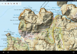
• মায়োর্কার Topo মানচিত্র: Mapa Topográfico নাসিওনাল 1: 50.000 & 1: 25.000 (আইজিএন MTN25 & MTN50)
• মায়োর্কার বেজ ম্যাপ: আইজিএন বেজ Topográfica নাসিওনাল 1: 25.000 (BTN25 & BCN25)
• মায়োর্কার কল্পচিত্র: উচ্চ রিসোলিউশনের খেচর চিত্রাবলী. পরিকল্পনা নাসিওনাল দে Ortofotografía Aérea (PNOA)
• জমি নিবন্ধন মানচিত্র: Cartografía Catastral
• OpenStreetMaps: এই ক্রাউডসোর্সড মানচিত্র অন্যান্য মানচিত্র স্তর একটি খুব দরকারী উপরন্তু. অনেক অনন্য বৈশিষ্ট্য ধারণ করে.
• OpenCycleMaps: এই মানচিত্র সাইকেল ভ্রমণের পরিকল্পনা আদর্শ
• ESRI সম্বন্ধীয়
• ESRI খেচর চিত্র
• ESRI রাস্তার ম্যাপ
• গুগল রোড ম্যাপ (অনলাইন এক্সেস শুধুমাত্র)
• গুগল উপগ্রহ চিত্র (অনলাইন এক্সেস শুধুমাত্র)
• গুগল ভূখণ্ড মানচিত্র (অনলাইন এক্সেস শুধুমাত্র)
• বিং রোড ম্যাপ (অনলাইন এক্সেস শুধুমাত্র)
• বিং উপগ্রহ চিত্র (অনলাইন এক্সেস শুধুমাত্র)
• পৃথিবী রাত
• Hillshading আস্তরণ
বহিরঙ্গন-নেভিগেশনের জন্য মুখ্য বৈশিষ্ট্য:
• তৈরি করুন এবং ওয়েপয়েন্ট সম্পাদনা
• Goto-ওয়েপয়েন্ট-ন্যাভিগেশন
• ট্র্যাক রেকর্ডিং (গতি, উচ্চতা এবং সঠিকতা প্রোফাইলের সাথে)
• Tripmaster ইত্যাদি দূরত্বমাপণী জন্য ক্ষেত্র, গড় গতি, জন্মদান, টিলা, সঙ্গে
• GPX / KML / KMZ রপ্তানি
• অনুসন্ধান (স্থাননাম, POI গুলি, রাস্তায়)
মানচিত্র দেখুন এবং Tripmaster মধ্যে • স্বনির্ধারিত datafields (উদাঃ গতি, দূরত্ব, কম্পাস, ...)
• সেয়ার ওয়েপয়েন্ট, ট্র্যাক বা রুট (ইমেইলের মাধ্যমে, WhatsApp, ড্রপবক্স, ফেসবুক, ..)
• ডিসপ্লে লাত / লন, UTM বা MGRS / USNG স্থানাঙ্ক (সামরিক গ্রিড / মার্কিন ন্যাশনাল গ্রিড)
• পরিসংখ্যান ও টিলা প্রোফাইলের সাথে রেকর্ড এবং ভাগ গানগুলি
• (ট্র্যাক আপ & উত্তর আপ) ঘোরান মানচিত্র
• মানচিত্রে দীর্ঘ ক্লিকের দ্বারা উচ্চতার করুন
• ট্র্যাক রিপ্লে
• এবং আরো অনেক ...
উপলভ্য প্রো বৈশিষ্ট্য: (প্রো বৈশিষ্ট্য উপলব্ধ ইন অ্যাপ্লিকেশন ক্রয় মাধ্যমে)
• অফলাইন ব্যবহার - কোন কোষ কাভারেজ প্রয়োজন
• সহজ + + ফাস্ট অফলাইন ব্যবহার (গুগল এবং বিং ম্যাপের জন্য না) জন্য মানচিত্র টাইল বাল্ক-ডাউনলোড
• তৈরি করুন এবং রুট সম্পাদনা
• রুট-ন্যাভিগেশন (পয়েন্ট-টু-পয়েন্ট ন্যাভিগেশন)
• GPX / KML / KMZ আমদানি
• সীমাহীন ওয়েপয়েন্ট & ট্র্যাক
• অন্যান্য ম্যাপ টাইল-সার্ভার যোগ
• কোন বিজ্ঞপ্তি
অফলাইন ব্যবহার:
সকল দেখা মানচিত্র টাইল ক্যাশের মধ্যে রাখা হয়. বিশাল এলাকা আপনি প্রো বৈশিষ্ট্য ক্রয় করার প্রয়োজন ক্যাশে করার.
হাইকিং, বাইকিং, ক্যাম্পিং, আরোহণ, অশ্বচালনা, স্কিইং, শাল্তি বাহিয়া যাত্তয়া, শিকার, offroad 4WD ট্যুর মত বহিরঙ্গন কার্যকলাপের জন্য এই পরিভ্রমন অ্যাপ্লিকেশন ব্যবহার করুন বা অনুসন্ধান ও উদ্ধার (এসএআর).
দ্রাঘিমাংশ / অক্ষাংশ, UTM বা MGRS / USNG ফরম্যাটে কাস্টম ওয়েপয়েন্ট WGS84 উপাত্ত সঙ্গে যুক্ত.
ইম্পোর্ট / এক্সপোর্ট / শেয়ার জিপিএস ওয়েপয়েন্ট / ট্র্যাক / GPX বা গুগল আর্থ KML এ / KMZ ফর্ম্যাটে রুট.
সেল সেবা ছাড়া এলাকার জন্য বিনামূল্যে মানচিত্র ডেটা পূর্বলোড (প্রো বৈশিষ্ট্য!).
মতামত ও mallorcamaps@atlogis.com করার উপাদান সংযোজনের অনুরোধ জানিয়েছেন
আমাদের অন্যান্য বহিরঙ্গন ন্যাভিগেশন অ্যাপ্লিকেশান কটাক্ষপাত আছে: https://play.google.com/store/search?q=atlogis
+++ আমরা কোনো ব্যবহারকারী কার্যক্রম ট্র্যাক বা কোনো ব্যবহারকারীর তথ্য সংগ্রহ করা হয় না! +++
Mallorca Topo Maps - Version 7.7.2
(22-03-2025)Mallorca Topo Maps - APK Information
APK Version: 7.7.2Package: com.atlogis.mallorcaLatest Version of Mallorca Topo Maps
Other versions


 3.64
3.64


Apps in the same category


